Chicago Midway International Airport (MDW)
Orientation and Maps
(Chicago, Illinois (IL), USA)
A city of commerce and skyscrapers, Chicago is actually home to a number of the highest buildings on the planet. Chicago is an unusual city, in that much of its skyline stands directly next to the beachfront of Lake Michigan, which stretches for almost 20 miles / 32 km.
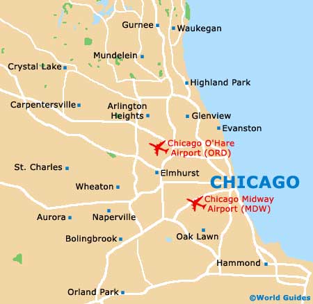
Chicago Midway Airport (MDW) is one of the city's two main airports and is located to the southwest, while the O'Hare International Airport (ORD) can be found to the northwest. Within the city, the Chicago Transit Authority (CTA) operates a reliable bus service and also a color-coded train network, including subway trains. Both of the airports are connected by trains along the CTA Orange Line and affordable taxi cabs.
Chicago Midway Airport (MDW) Maps: Important City Districts
The main heart of the downtown district is the Loop area. Much of downtown Chicago is structured as a gridwork of roads and blocks, with an important Theater District and also a large number of top nightspots, many of which can be found where West Randolph Street and the North State Road meet.
Outside of the downtown area you will discover a collection of districts and neighborhoods. Maps are useful when getting around in this area and are available from many of the city's bookstores, such as the Savvy Traveler along South Michigan Avenue. The city's numerous tourist offices will also be able to provide in-depth maps of the area and a useful 'CityPass', which enables you to save money when visiting the city's main attractions. Chicago's tourist information centers can be found along East Randolph Street, the Navy Pier and East Pearson Street.
United States Map

Illinois Map

Chicago Map